“Keep the best sites to yourself.” That’s what the late, great eco-activist and fellow nature writer, Edward Abbey, would have advised me if he knew I was writing an article about the top walking trails in and around Yellowknife. But sorry Ed, I want to celebrate the “best sites,” champion them, keep them on the map. The question is, how to pick them?
Local rockhounds, birdwatchers or dog walkers may search this list in vain for their favourites – the sandpits near the airport for example, or what about that big rock knob behind Weavers’ store, or…
Wait. I don’t have much space here. I’ll have to stick to sites that meet all of my pet criteria:
• Outstanding natural features
• Easy access• Big enough to lose yourself in• Well-trodden and much loved by me
So here goes. My half-dozen favourites – three in town and three along the Ingraham Trail. Odometer readings are from the Explorer Hotel.
FRAME AND JACKFISH (aka STOCK) LAKES
Yellowknife’s Natural Hub
Yellowknife’s distinction as a “city in the wilderness” is driven home after a stroll around these two aquatic centrepieces of the community. Over eight kilometres of easy, all-season walking trails — with benches and interpretive plaques along the way — will take you around Frame Lake or, via Jackfish Lake, all the way to Highway 3 near the main access to Fred Henne Park. The most popular access points for the Frame Lake trail are right behind the Northern Frontier Visitors’ Centre, the new Somba K’e Park by City Hall, and off the main road to Stanton Hospital (Catalina Drive). You can access the Jackfish Lake trail at the north end of Lakeview Cemetery, off Highway 3 just east of the Fred Henne Park entrance, or via a connecting trail at the north end of Frame Lake.
The lakeshores and adjacent terrain include everything from long stretches of flat sandy beach to rugged bedrock cliffs over 30 metres high. The undulating topography and varied aquatic habitats found here contribute to this area’s diversity of plant communities, birds, and wildlife. Many fine viewpoints offer impressive vistas of the city while others give an impression of remarkably unspoiled wilderness.
NIVEN LAKE – Urban Oasis for Wildlife
Named after one of Yellowknife’s first mayors, the two-kilometre trail around Niven Lake can be accessed from the east along Niven Drive (by the mailboxes), from the west through a public easement off De Weerdt Drive, and from the south off Highway 4 by the transformer station, just past the Explorer Hotel. It has two very different faces. The southeast shore nearest town is graced with a wide, smooth trail that is suitable for bike and wheelchair access. The opposite shore is much more rugged, though easily negotiated on foot, going over high rock outcrops and offering splendid views of both Niven Lake and Great Slave Lake. Numerous benches along this scenic loop trail are well placed for wildlife viewing, picnics or a quiet mid-afternoon siesta.
What makes Niven Lake special is the ecological diversity it offers so close to downtown. The lake was selected as a lagoon soon after Yellowknife moved up the hill from Old Town in 1947. It received over 30 years of sewage, which had a tremendous fertilizing effect on the entire ecosystem. Since its closure as a lagoon in 1981, the lake has returned to a relatively natural state.
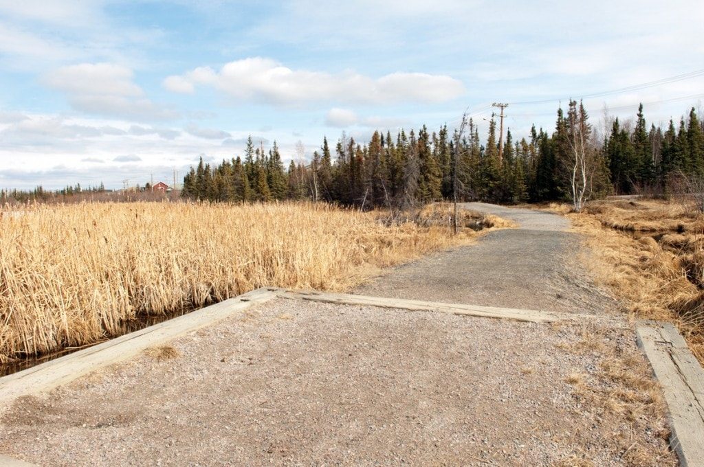
Niven Lake
PROSPECTOR’S TRAIL – Pillows, Plutons and Pockets of Gold
Hundreds of tourists, students, geologists and curious Yellowknifers have strolled down this four-kilometre, family-friendly trail since it was developed as a Fred Henne Park attraction in the mid-1980s. Found at the north end of the territorial park, located along Highway 3, this trail is marked by small white prospectors painted on the rocks and bright-coloured flagging tape. Besides being an exceptional showcase of Precambrian geology, the trail takes you through several kinds of habitats, from dry, lichen-spattered bedrock to rich cattail marshes alive with birds and aquatic mammals. Ask the folks at the park gatehouse for the numbered, interpretive guide that explains many of the cooler geological features.
It was right here that Yellowknife’s first mineral claims were staked by Norman Jennejon when he discovered the gold that led to a massive staking rush, and the eventual establishment of the Con and Giant mines. The several rock trenches crossed by the trail were blasted by eager prospectors in the 1930s and ‘40s. Remains of several tent platforms and a privy date back to this time when gold-studded dreams abounded.
RANNEY HILL & MARTIN LAKE – An Elevating Showcase
Seen from any high rock outcrop or office building in Yellowknife, the wild landscape north of town rolls gently away, flat to the horizon, in typical Canadian Shield style. The Martin Lake trail is situated along the Vee Lake road, which meets the Ingraham Trail 6.6 kilometres north of Yellowknife. Slow down at the last major right-hand curve towards Vee Lake and stop when your odometer reads 11.4 kilometres from town. Look left for the trailhead, a gap in the roadside willows, usually marked with flagging tape.
Scattered amidst this undulating plain of rock are a few pronounced domes and ridges that look almost out of place. One of the highest and most accessible of these promontories is Ranney Hill, an isolated mound of volcanic rock that rises like a dark fortress above a sea of pink granite.Named after Bill Ranney, one of the many prospectors who swooped into the region in the 1930s, this mini-mountain is best climbed from the southwest flank and is situated about halfway along the Martin Lake trail. The two-kilometre hiking path takes you through a diverse mix of forests and wetlands, past secluded David Lake, which is a favourite breeding spot for many water birds.
BIGHILL LAKE TRAIL – Sedimentary Sea
An easy 20-minute drive east of Yellowknife along Ingraham Trail takes you to the rarely travelled Bighill Lake trailhead, and into the heart of a former marine basin now filled with sedimentary rock. When Madeline Lake comes into view and your odometer reads 24.4 kilometres from town, look right for a rough vehicle trail that leads to an old borrow pit. The trail itself starts at the southeast corner of this pit and is usually marked with orange flagging tape.
Traverse the roots of Precambrian mountains and ponder their demise as you walk south towards Bighill Lake. About halfway along this 6.5-kilometre trail, you come to a high ridge offering breath-taking views of raw Shield wilderness broken only by the skyline of far-off Yellowknife. Red arrows painted on the rock mark parts of the trail. Some stretches are straight and unmistakable with the bedrock as smooth as a sidewalk. Other stretches have sudden jogs and can be confusing. If you think you’ve lost the trail, backtrack until you find a familiar spot then look for areas where foot traffic has worn lichens off the rocks. Expect several ups and downs along this trail, which ends at a low sloping rock outcrop along the stunning shore of Bighill Lake. Stop for a picnic or bring a tent and camp for the night.
CAMERON FALLS TRAIL – Cascades and Crowberries
Magnificent Cameron Falls is one of the most visited natural wonders in the Yellowknife region. The Cameron Falls parking lot is located 2.3 kilometres beyond the Powder Point boat launch at the east end of Prelude Lake, or 48 kilometres from Yellowknife. A rolling 20-minute hike to the falls takes you through a diverse mix of forests and over a fascinating showcase of sedimentary rocks. This one-kilometre trail offers a pleasant family adventure and is suitable for children, but take extra caution along its steeper portions, especially around the cliffs above the falls. Be sure to follow the trail that leads upstream to take in the dreamy footbridge that spans the river just above the falls
The falls, and the river that stretches many kilometres above and below them, are named after Allan E. Cameron, a geology professor from Edmonton’s University of Alberta. During his many trips to the Yellowknife region in the 1930s, he shed much light on the local geology and left behind a legacy of field maps that guided the footsteps of many prospectors who followed.