Yellowknifers have a keen interest in the city’s past, but historian Ryan Silke takes that to new levels. In this inaugural installment of a new series looking at YK firsts, Silke takes us back to our rocky beginnings.
Rocks have feelings too. I don’t know if scientists have proven this yet, but from an early age I was taught to appreciate the innocuous stone beneath my feet because of the stories it can tell. And so I thought it fitting to introduce this regular feature on Yellowknife history by talking about the rocks and minerals that are all around us.
Without a doubt the study of rocks is an incredible lesson. All of the evidence for billions of years of Earth history can be read from outcrops within easy reach of the city. If you find it hard to comprehend millions and billions of years, don’t be disappointed…be amazed at how long it took for the rocks around you to be laid down and reshaped. That in itself makes the outcrops in your backyard worthy of respect.
Mountains of Lava
In the NWT we have evidence of rocks that are four billion years old, remnants of ancient continents that formed and died as a result of plate tectonics; the movement of the large plates that form the earth’s outer shell. The rocks around Yellowknife are younger, a mere 2.7 billion years, laid down by volcanoes on an ocean floor.
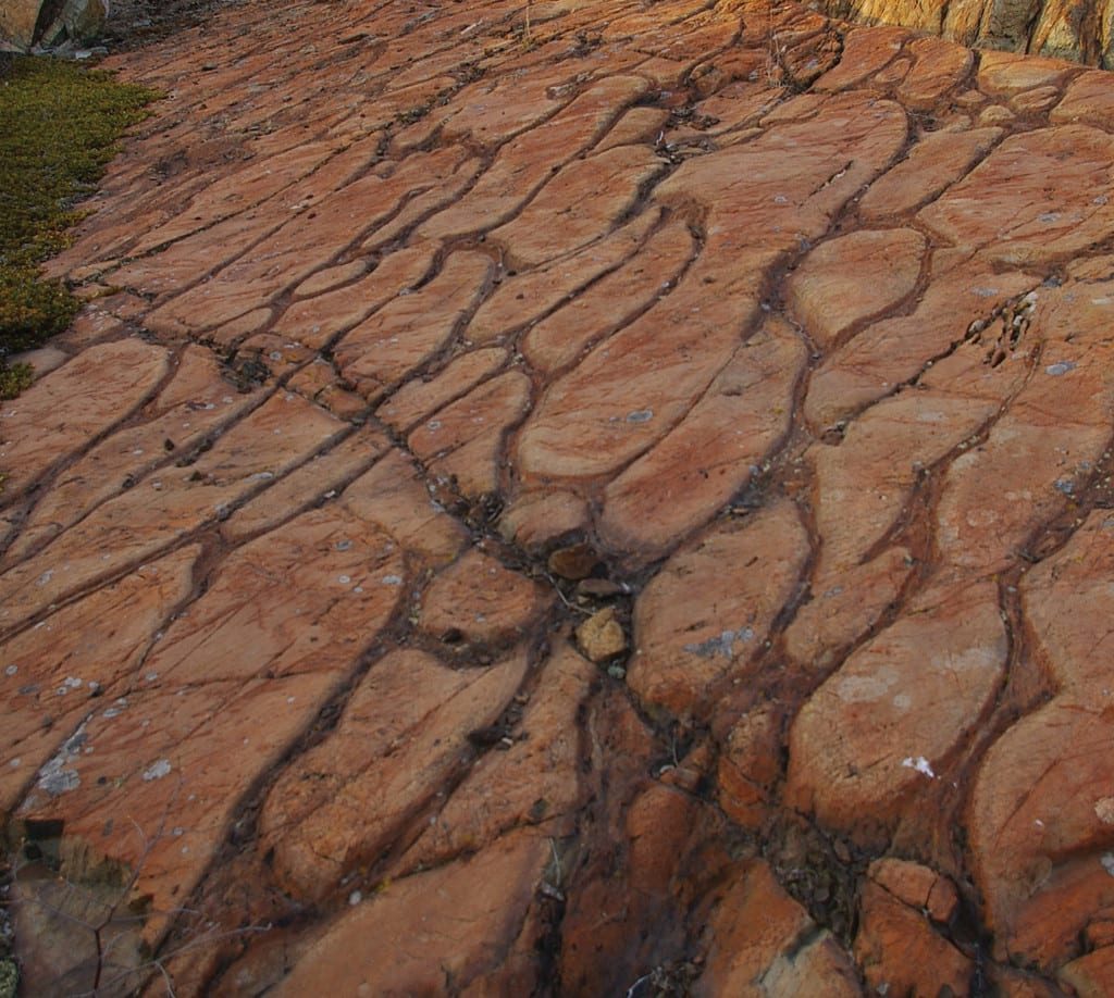
These eruptions make up the Yellowknife Greenstone Belt which extends up the river for 100 km. Greenstone refers to the greenish, hard rock known as basalt that formed when bits of lava shot out of volcanoes. Many of the basalts have a circular ‘pillow’ shape. These round patterns are proof that the lavas erupted underwater, the shells of the flows cooling very quickly as they hit the water. You can see this happening today in Hawaii.
A layer of basalt rock over 10 km thick was formed over millions of years, creating a series of shield volcanoes in the middle of an ocean. Later, another series of volcanoes erupted, a significant tectonic event that must have shattered the landscape. You can see blasted chunks of rocks encased in hardened volcanic ash (breccia) preserved along the shore of Yellowknife Bay near Giant Mine.
The cracks where magma flowed are often still visible. Magma is the molten rock stored beneath the earth’s crust that turns into lava when it reaches the surface. A favourite destination for hikers, Ranney Hill off the Vee Lake road, is a prominent landmark that could be the hardened magma chamber from a volcano.
Invaded with Granite
One-hundred million years after the volcanoes stopped erupting, a new period of volcanism struck, hidden deep from view, creating the granites that extend from Yellowknife to Behchoko. This magma did not flow onto the surface; it came up and intruded within existing layers of rock. The granites are a distinctive pink rock, coarse-grained with large crystals due to a slower cooling below the crust.
During the rising of the granite magma, the layers of basalt above were bulged, tilting the landscape. After millions of years of erosion, the granites are now exposed and often form hills above the other less-resistant outcrops. Next time you are on the highway driving past Jackfish Lake, look for a contact between the green-grey basalts and the intruding pink granites.
To the east of Yellowknife Bay along the Ingraham Trail there is a different type of rock. These are sedimentary in origin, formed through the natural erosion and weathering of the mountains into an ocean. These rocks were also warped and folded as a result of granites that came up around Prelude Lake. You can see the layers of cooked sediment at Burwash Point that now stand vertical because of the deformation. On the Big Hill Lake hiking trail, one may also observe crystallized ‘boils’ known as cordierite, a tell-tale sign that a 500° C metamorphic event took place.
Injected with Gold
Many world-class gold deposits can be found along greenstone belts and Yellowknife is no exception. Solutions soon came up from the mantle creating the mineral deposits that the city is known for. Gold is hosted in two structures: quartz veins and shear zones. Both are the result of fractures in the original host rock providing a conduit for mineralized fluids to come to the surface, sometimes carrying precious metals with them.
During the Proterozoic era, 1.9 billion years ago, new faults opened up in the hardened shield. The West Bay Fault is the most prominent. It strikes along the west side of Yellowknife Bay. It was responsible for splitting the Con and Giant gold deposits in half, but thankfully the fault is no longer active!
Carved by Glaciers
It is important to understand that the land we see today – the hills, valleys, lakes, rivers – are young in the scheme of geologic time. They are the result of the most recent period of glaciation that ended 15,000 years ago. Over millions of years, successive ice sheets scoured down kilometres of the original rock layers.
When they finally receded they left behind valleys, striations on the outcrop, erratic boulders, and eskers. Most of Yellowknife is built on a shallow sand plain created by rivers from glacial melt.
The end of the ice brought life back to the continent. New species of plants and animals flourished. Soon to follow were waves of humans who came into the northern hemisphere to attach meaning and cultural use to the land. Four billion years of geologic process had warped the landscape into a treasure house, and it was inevitable that people would learn the secrets of the rocks and minerals.
To be continued….
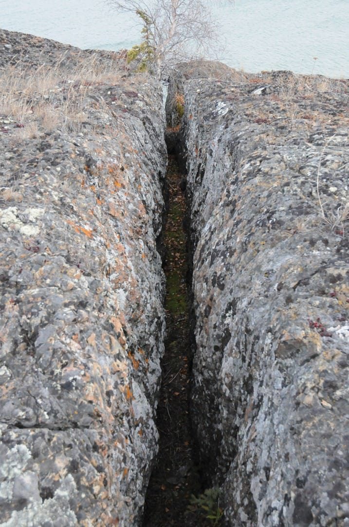
A distinct fault, cutting down an outcrop on Yellowknife Bay.